Strayos' Flagship Webinar Was a Fantastic Success
The Untapped Potential of Drone Data in Drilling & Blasting
Strayos, in collaboration with Maurer & Scott, hosted its first Webinar on September 29, 2020. It was an amazing success. There were more than 300 registrations and over 100 attendees from countries all over the world. The excitement was palpable and the audience was fantastically engaged.
Ravi Sahu, the CEO of Strayos began the presentation by first discussing the evolution of face profiling techniques and then introducing some of the AI solutions offered by Strayos to improve drilling and blasting operations.
Zach Tobias brought it home by sharing the benefits his company, Maurer & Scott, realized when they began using drones and AI at their operations. He shared several real use of drone face profile and stories of avoiding flyrock disasters because of the 3D face profiling using drones.
If you would like to watch the webinar at your convenience, we are providing it on-demand here: Replay link
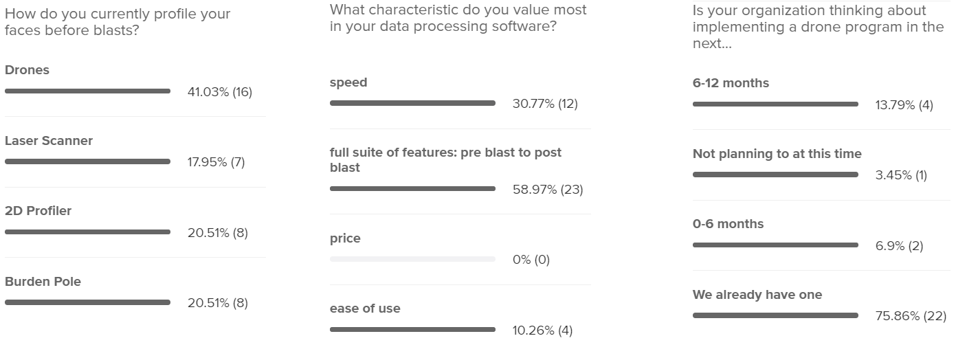
Interesting facts we learned from our audience:
41% use drones to profile their benches before blasts, whereas 18% use laser scanners, 20% use a 2D profiler and 20% use a burden pole.
The characteristics most valued in their software selection was a comprehensive product with a full suite of features from pre blast to post blast (60%) and speed (31%).
Finally we learned that of the respondents for the 3rd poll question, 76% were already using drones in their workflow, 21% were planning to start using drones within the next year.
Q&A
While Ravi and Zach tried to answer as many questions as they could in the remaining Q&A time, there were far more than were possible. So, in keeping with Strayos' belief that more information is better, we are sharing those questions and our answers to them below.
1. Do you have own solution for drone pictures processing?
Yes, Strayos has developed its own photogrammetry solution to process the drone pictures.
2. Is it more efficient than Metashape in terms of processing time?
We have not compared the efficiency directly to Metashape but on average for approximately 60 images, a 3D model will be generated in approximately 45 minutes in cloud based application and in Standalone version it could take upto 75 mins.
3. What is the accuracy of the created model?
The model itself is accurate to reality for all referential 3D model information, for survey grade accuracy in exact geo-location a centimeter-level accurate GPS must be used in conjunction with the platform.
4. How deep can you go in analyzing geological and geotechnical data at the moment?
Strayos Rockmass AI can detect geotechnical features of higwall such as joints, bedding plane and discontinuities based on RGB drone pictures. RGB cameras in drones are limited to gather deep subsurface geological information, but if you were to use a hyperspectral camera or another geophysical sensor which can help gather this type of information and then we would be able to interpret it.
5. Does the software consider explosive type/output, i.e. energy factor, in the placement of holes along the crest or just the geometry?
The software has the ability to optimize the front row of holes based on a user-inputted constraint of what the minimum burden they need is. Our platform will change the placement of either the collar or the toe of the hole to optimize the burden.
6. AI collar deviation calculation? Is that solution is developed by you or you use? for example Epiroc drill rig deviation calculation.
The AI detection of Collar deviation is developed by Strayos to analyze the images to find the actual drill hole.
7. Is there a user guide available to download?
Yes, We frequently update our user guide link and we also have a Youtube channel where we post weekly Strayos Academy tutorials.
User Guide link
Strayos Academy channel
8. Which manufacturers provide drill rigs with MWD? Epiroc...?
Popular smart drills OEM are Epiroc, Sandvik, Caterpillar, Komatsu. There are aftermarket MWD products also available which can be installed into a older generation of drill rigs. To name few such as Thunderbird, Flanders, LIM
9. For the smart drill locations, can those be exported and thrown on a local coordinate systems? or published only?
Yes, They can be transformed to be represented on any coordinate system.
10. Is the muck pile after blasting? Do AI tools provide the fragmentation (internally) size / boulder size?
Yes, Strayos Frag AI can determine the fragmentation size of a muckpile based on the 3D model. This information can be easily represented into a Particle Size Distribution chart.
11. So what is the manufacturer goal to manufacture DJI inspire class drones if DJI Mavic pro can be easily used?
We can't speak for the drone manufacturers because one drone doesn't fit all the requirements and certainly each hardware has its own benefits and outcomes.Larger drones such as DJI Inspire have the ability to handle themselves in more difficult wind conditions and the payload capacity also increases with better battery life.
12. A cloud-based solution sounds great; however, many mining and mining-related operations occur in remote and harsh terrains with little or no access to a form of network connection. Do you offer a hybrid of offline-cloud solution to solve this challenge?
Yes, Strayos offers an offline version of the application to process images in local machines, create shot plans, and do face profiles.
13. Does the drone data facilitate for real time volume analysis of the material carried in a Dumper body?
The nature of drone data is that it represents an image and that only allows us to look right at the moments being captured. We do have additional solutions to analyze real time volumetric information such as cameras mounted at a fixed location like the primary crusher that may help in real time volume analysis.
14. How many hours does it take the app to create haul road/blasting analytical report?
The no. of hours is directly proportionate to the number of total images to generate the final photogrammetry model but the actual AI results to create haul road/blast report only takes 5% of the time from the final model.
15. How do you predict hard toe holes?
The platform can indicate that there will be hard toe by incorporating MWD(Measure While Drilling) data and shot plan data.
For example, if the penetration rate of the drill is very slow, we can reasonably estimate that area is a harder strata. Also, in terms of excessive burden, the platform does create face profiles throughout the length of the drill hole to measure your burden at exact downhole locations.
16. What is the calculated by AI deviation accuracy in relation to boretrack? Have you compared boretrack vs AI deviation prediction?
The AI only has the ability to detect the information it has access to, so in this case the model itself, so it only can find the collar of the hole. This information is accurate and can be shown because it appears over the actual drilled hole on the 2D orthophoto. Strayos accepts boretrak data to measure and visualize the true deviation.
17. Are there any changes coming to the stockpile volume aspect of Strayos? Comparative to other programs I feel there are too many options available that create too much user error.
Great question, we give many options because we don't want to give a user information where we made an incorrect assumption about the base plane. Strayos provide different bottom planes (linear, average, manual elevation etc.) to ensure the measurements are accurate for each specific stockpile. For more information on the specifics of why we do this here is a great video talking about the stockpile module.
18. Is there scope to identify the fragmentation size in the muckpile ( internally also) after blasting on real time basis, which may guide us to deploy a Excavator or a wheel loader based on the fragmentation, toe formation etc.
The typical drone RGB pictures provides the fragmentation analysis for surface and visible layer. If you are looking to analyze the particle size below the surface then hyperspectral camera sensing system which can be attached to a drone.Hyperspectral camera sensors can reflect sub-surface properties for internal muckpile data.
Regarding the real time fragmentation, machine mounted camera in a shovel, loader or excavators provides analysis in real time. This can help to understand the process better, whether it is crushing, grinding or diggability better and improve crusher throughput overall.
19. What GPS Hole Placement Equipment do you use and also what Bore Tracking Equipment do you recommend and is compatible with Strayos?
Strayos platform has the ability to accept files from any GPS equipment or Bore Tracking equipment.
20. After reading the MWD data in the software. What practical treatment applied to the blasting does the software give to improve the operation? For example, selective charging, fragmentation predict and etc.
Strayos currently allows the users to make that decision based on the MWD visualization and comparison with 3D burden. For example, if you see that 7m down the hole the penetration rate is lower than normal then as a blaster I have plenty of options to choose from to effectively blast through that material.
21. How does AI help in predicting fly rock position both in pre & post blasting?
At the moment, Strayos platform doesn't have flyrock prediction.
Currently, Strayos provides Muckpile prediction AI based on different blasting and rock parameters for pre blast scenarios.
22. How does photogammetry data compare to LiDAR data?
LiDAR and photogrammetry has its own benefits and both have different ways of capturing the data. LiDAR provides good accurate datapoint when its used in dense vegetation landscape while photogrammetry may not be the first choice when mapping dense vegetation. For bare earth data collection like Mining terrain - photogrammetry is equally comparable in accuracy with LiDAR and the ease of use with low cost is a bonus.
23. Is AI part of Strayos for analyzing recorded pictures by drone? or it includes blast design based on recorded data from past or project limitations like blast vibration.
Strayos AI is designed to run on recorded pictures and with more historical data the AI keeps getting better for the specific site.
24. We use Montabert Drill attachments and we require some GPS Drill Data systems for our Montabert units. Which GPS Drill Data Systems will work best with Strayos?
Strayos is compatible with most of the drill rig files and we use industry standard file system such as IREDES which is acceptable to common OEM and after market attachments as well.