Freeing Up the Geotechnical Engineer
Geotechnical engineers are some of the most highly trained personnel on a mine site. Yet, far too much of their time is spent manually mapping pit walls with a compass and clinometer, exposing themselves to the active highwall face.
Building a baseline understanding of a site starts with exploration and core sampling. Lab tests determine the chemical signature of these samples, which is then utilized to create a block model. But translating that sparse, single-point borehole data into a continuous 3D understanding of the pit wall takes massive amounts of manual interpolation.
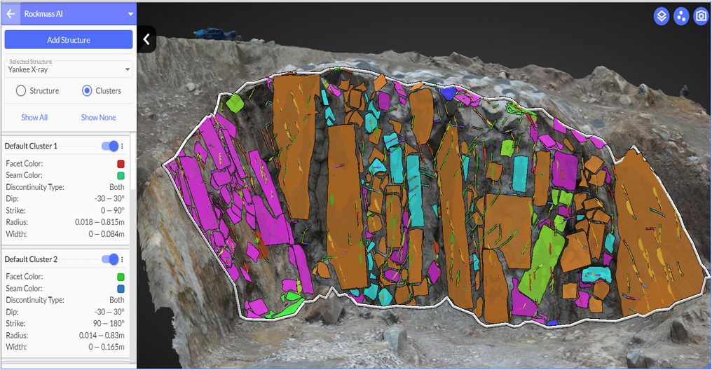
Automated Rock Mass AI does not replace the engineer; it replaces the tedious data collection. Instead of manually recording joint strikes and dips, automated facet mapping instantly identifies and maps 3D flat planes across the entire site using drone imagery. This allows engineers to spend their time analyzing the data rather than simply collecting it.
Visualizing Risk Before the Blast
Hard rock fails along intersecting structural defects, not as a uniform mass. When engineers lack an up-to-date structural model, the operation faces major challenges in design conformance.
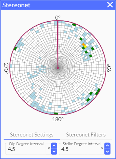
By utilizing automated stereonet visualizations, teams can see 3D discontinuities mapped cleanly onto a 2D plane to identify the primary families of fractures. The software calculates a safety factor for slopes, ranging from 1.0 (higher risk of failure) to 1.5 (unlikely to fail). This gives the team color-coded visual output to spot failure risks before a single blast takes place.
Empowering Human Expertise
The introduction of AI into geotechnical workflows is about giving human experts the best possible starting line. The software assesses risk by identifying potential failures, but it does not independently dictate how to fix the mine. Users must rely on their own geotechnical engineering expertise to decide on specific interventions, such as adding containing walls or avoiding specific base points during blasting.
By eliminating the manual grind of data collection and providing rapid safety factor analyses, Rock Mass AI allows engineers to focus on what they do best: designing safe, highly efficient, and predictable mining operations.
Q&A
Q: How does Rock Mass AI save my engineering team time?
A: It automates the tedious field data collection process. Instead of manually mapping joint sets on the bench, automated facet mapping identifies 3D flat planes across the entire site instantly using drone data.
Q: Does this software replace the need for a geotechnical engineer?
A: Absolutely not. The software assesses risk by calculating safety factors and identifying potential failures, but it relies on human geotechnical engineering expertise to decide on interventions and remediation.
Q: How does the software predict if a highwall is going to fail?
A: It runs Limit Equilibrium analyses to calculate a safety factor for the slope. A safety factor of 1.0 indicates a higher risk of failure, while 1.5 is considered stable and unlikely to fail.
Check out a Demo!
https://youtu.be/cTqaenuRSvo?si=vSUsgkyBCVafAiof
#MiningEngineering #Geotechnical #DrillAndBlast #RockMassAI #MineSafety #Surveying