Webinar Summary | Smarter Stockpile Surveys
Webinar Replay:
Webinar Slides
Summary:
Getting a stockpile volume is easy, but getting a number you can trust at month-end & year-end takes more. Changing pile boundaries, inconsistent flights, & uncertain base surfaces throw off your inventory. Small errors compound until reconciliation becomes a write-off & a difficult conversation with management or finance.
Alex Applebee, Field Operations Manager at Aerial Data Labs (ADL) shares what he sees across client sites: Where stockpile surveys go wrong, which processing problems come up most, & practical changes that make data capture & processing faster & more defensible.
New Stockpile tools:
- Dock automation: Scheduled flights keep inventory current
- AI updated stockpiles: Update previous polygons- save time & boost efficiency
- Segmentation AI: Auto pile detection & boundary delineation cuts manual toe-drawing & keeps results consistent
- Practical tips: Improve base surface selection, processing, & reporting
You’ll learn:
- The most common causes of stockpile volume measurement errors, and how to prevent them before you fly
- How to capture data, process for accuracy & speed across many different sites
- How dock-based automation is creating value by streamlining time & results
- How AI segmentation handles touching piles, irregular toes, & changing stockpile layouts
- How to get more value from every inventory flight across your operation
Polls:
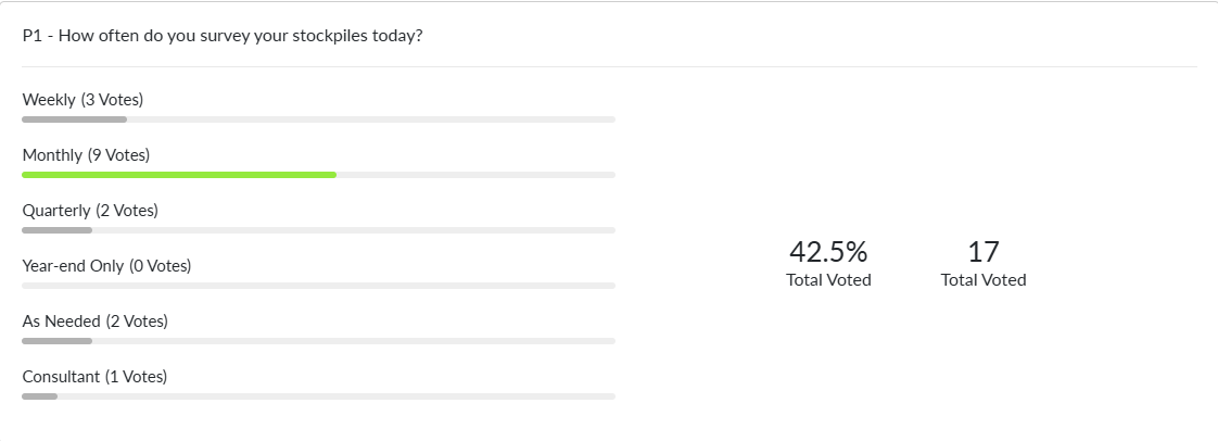
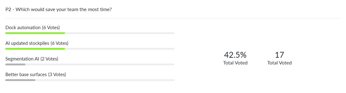
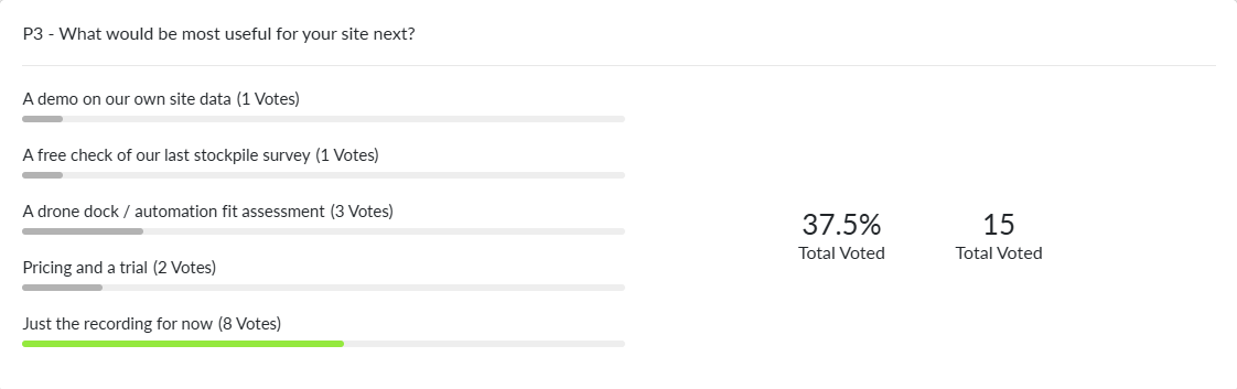
Q&A:
Q. We’ve been looking at smart, self-correcting GCPs like AeroPoints, but they’re pricey for the number of points we’d need. What do you recommend for GCP targets on a budget? And how many do we really need with an RTK or PPK drone?
Ans- Targets: For temporary targets, spray-painted marks (usually an X) work well. For something semi-permanent, black-and-white checkerboard vinyl tiles are a great option. They cost about $0.25 each on Amazon and typically last 6–12 months on site. Pair them with your GPS and an RTK correction subscription (such as RTK USA or GEODNET, roughly $400/year). A vinyl tile is far cheaper and easier to replace than a smart GCP.
How many: It depends on the size of your area of interest. As a starting point, use at least 3 GCPs with an RTK drone and at least 5 without. Add a few extras in case one gets destroyed or covered, and spread them evenly across the area.
Q. If we use fragmentation AI. Then can we change the results manually?
Ans - Yes and no. The measurements come from the processed geospatial data, so the underlying results can’t be edited. What you can control is what gets measured and how it’s reported: -The area Fragmentation AI analyzes -The size settings that are displayed -How fragmentation is measured for the particle size distribution (PSD): minimum, maximum or average rock diameter
Q. Amongst the stockpile outputs by Stockpile AI in Strayos, Truck Dispatch data, Material inflow data from FMS, which one can be considered as a true value?
There’s no single true value. The most trustworthy source is the one with the highest verified accuracy. Often that’s the stockpile survey. At some sites, though, a calibrated scale (belt scale or weighbridge) is the most accurate measurement available, so it becomes the reference. The goal is to use the best-verified source as your baseline and reconcile the others against it.
Q. How can I select appropriate base layer for my site?
Ans. The ideal base layer is a surface captured when the area was empty and verified by everyone involved. Once it’s agreed on, you can use it for every survey going forward, which removes one of the biggest sources of variance in your volumes. If you don’t have an empty-ground capture, the visualization tools help you check exactly what material sits above the base, so you can confirm it’s being counted correctly.
Q. Some of our material is in a dome or covered shed. Can drones or docks handle that, or do we need something else for those piles?
Ans. A few drones can fly indoors, but photogrammetry usually isn’t the right tool. Low light makes it hard to reconstruct the surface, and propwash can kick up fines that show up in the imagery.
LiDAR is the better fit, whether it’s drone-mounted, handheld (SLAM) or a static scanner. It produces a laser point cloud you can measure directly. Strayos can ingest LiDAR data, but it needs to be georeferenced and cleaned before import. Once it’s in, you can run volumetrics alongside your outdoor piles.
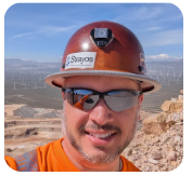
Speaker

New technologies are rapidly changing the drilling, blasting, mining, and aggregates industries, empowering them in ways never before possible. Make sure you are taking advantage of the best tools available.
Check out our 2 Free E-books on AI applications for the drilling, blasting, and mining industries to see all the amazing advances that are available.
AI Guide for Drilling and Blasting
AI Guide for Mining
Watch our videos:
YouTube