How Drone Data is Empowering Boretracking Operations
Knowing the true path of as-drilled holes is critical for effective blast design. Accurate burden measurement is necessary to prevent flyrock, minimize airblast & optimize fragmentation. Combining drone and boretrak data has made it easier than ever to take advantage of this much needed information.
Strayos' AI takes data captured by drones to build incredibly accurate 3D models of your bench. Blasters can design their shot plan and send it to the drillers for drilling. Once the drilling is complete simply measure the "as-drilled" holes and add that data to see your shot like never before. With this digital twin, drillers and blasters can see inside their bench, measure the "as-drilled holes'" deviation from the plan and improve future drilling and loading operations.
Traditionally, the logistical challenges of boretraking have made it impractical for many companies to implement across all of their sites. Maine Drilling & Blasting has leveraged drone data and Strayos' AI to overcome these challenges and expand their boretraking program.
Read on for a written summary of the Webinar hosted by Strayos and Presented by Maine Drilling and Blasting's experts Aaron Flewelling and Zadock Emerick.
If you'd rather watch the webinar- you can view the recording here.
Introducing: The Presenters!
From Maine Drilling & Blasting
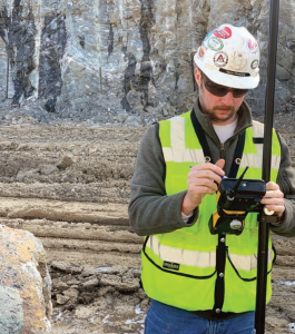
Aaron Flewelling, Manager of Engineering & Technical Services
Has been with Maine Drilling and Blasting since 2010. During his tenure, Aaron has been involved with the estimating through completion for hundreds of drilling and blasting projects throughout the Northeast and Mid-Atlantic markets. He began managing the department in 2018. The engineering and technical team has grown to 25 employees performing tasks such as boretracking, surveying, estimating, takeoff, blaster education, and technical evaluation among other assignments.
and
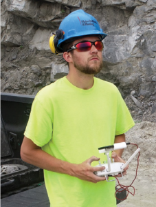
Zadok Emerick, Quarry Field Engineer
Has been with Maine Drilling and Blasting since 2018. Zadok has been responsible for training and mentoring the current boretracking team of 5 technicians. He has performed over 1,000 deployments of the drone and boretrack system using Strayos. Zadok evaluates new products and deployment methods for the team to ensure efficiency in operations are maximized.
From Strayos
Ravi Sahu, CEO
CEO of Strayos a cloud based software company that develops Drone Data Analytics and Artificial Intelligence solutions for the Drilling, Blasting, and Mining industries. Formed in 2016, Strayos is used in hundreds of sites all around the world.
The Audience
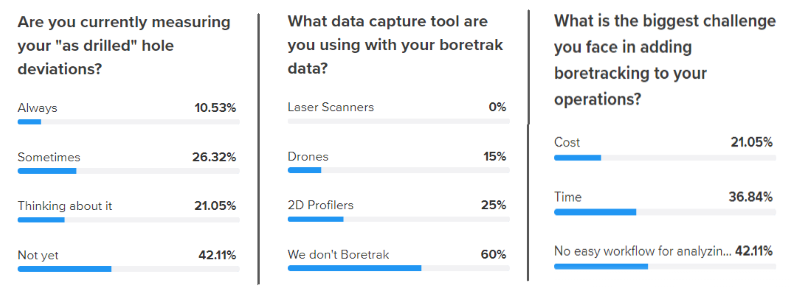
200 people registered from all around the world to learn more about how to combine boretrak data with drone data and get their best blast. They shared with us their biggest concerns.
A little bit about Strayos
The Presentation started with a brief introduction of Strayos by CEO Ravi Sahu including an overview of the company
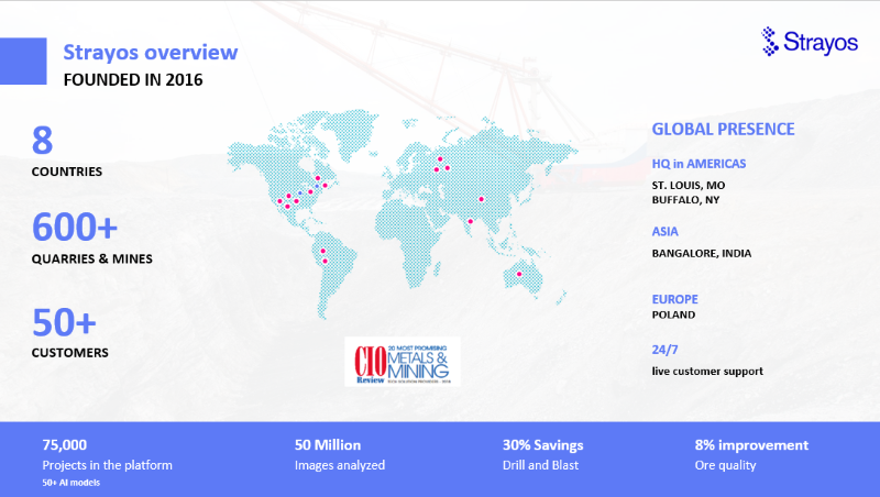
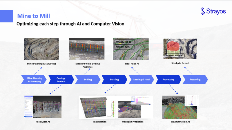
and a walk through of Strayos' Mine to Mill platform with solutions designed to maximize every phase of your site's operations. Including mapping (2D and 3D), geological analysis (including Rock Mass AI & hyperspectral imaging), drilling analytics (drill plan design, measure while drilling, & hole deviation measurement), blast optimization (including blast design, burden analysis, & fragmentation and muckpile shape prediction), loading and hauling (Including Haul Road AI and Haul Truck Engine Optimization), processing (including fragmentation & hyperspectral imaging), and reporting (including stockpiles).
A little about Maine Drilling and Blasting.
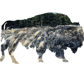
MD&B is represented by the American Bison- Powerful, Fast, & Enduring.
Maine Drilling and Blasting was started in 1966 as a family business in Gardiner Maine. In 2004, an Employee Stock Ownership Program was established giving employees a stake in the company.
Today they service quarry and construction projects throughout the Northeast, Mid-Atlantic, and Southeast regions. They have a broad in-house technical services and engineering team that provides services like
- Boretracking and Drone Data Capture
- Blasting technical representatives
- Estimating
- Surveying
- Value Engineering
In 2018 they began investigating drones due to the rising cost and hassle of 3D laser repairs. They needed a more efficient solution. They quickly found that Strayos enabled them to scale up their surveying and boretracking program.
What is Boretracking and Why Should We Do It?
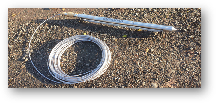
Boretracking is a method of measuring "as drilled" holes. A probe is lowered into the drilled hole that meaures the pitch and role of the probe sensor at pre-set intervals. This information can be added to Strayos' 3D model of the bench. This allows the software to calculate actual burdens of the holes at different locations and measure hole separations for optimized loading. It can be compared to a shot plan designed in Strayos on the bench to measure drilling deviations.
Knowing actual burdens and hole separations allows for dramatic improvement in fragmentation and blast safety results. Having this information gives a blaster much more confidence in the shot.
Examples of Boretracking "Saves"
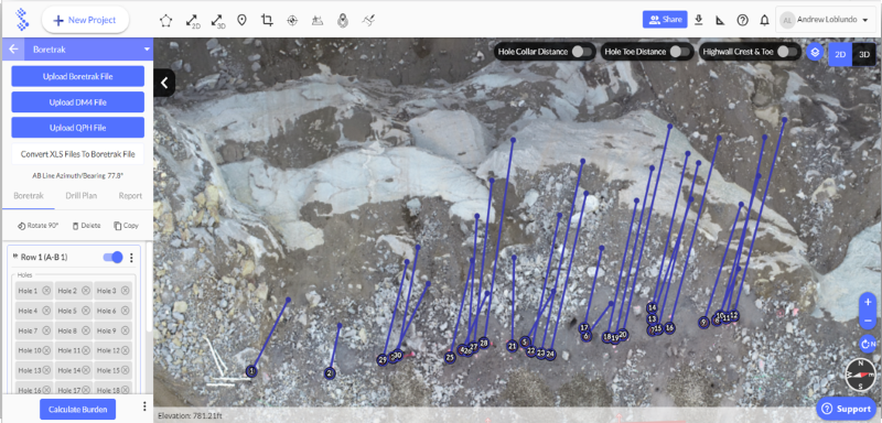
Here was a shot with a challenging geology and some pretty tight quarters. Its about 400 feet off a four lane highway and 100 feet away from a building the quarry owns.
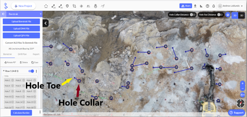
The picture above is a view of the top of the 3D model of the bench. The the dark circles with numbers represent the hole collars and the blue lines reaching out from the the dark circles showing the distance and direction of the hole toe.
Holes 30, 31, 34, and 35 were all very close together and didn't go where they were intended to be. They were deep cuts- about 70 feet and the geology was quite challenging. So they ran some deviation and found holes 31 and 35 were about two feet apart at the bottom of the hole- a serious issue in such tight quarters.
"If there's not enough burden at the bottom of the hole you can essentially turn a four inch hole into an eight inch hole and there's twice the product you intend there to be."
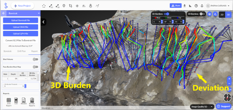
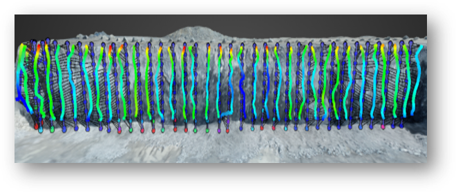
Here is another view of the 3D model with the bore-track data showing the face of the bench- this shows 2 sets of data points that clearly illustrate just how messed up the face was. The squiggly colorful lines show the shortest distance from the hole at any designated spot to the face (the 3D burden)- they are all over the place. The colorful dots on the shot design show the amount of deviation from the design- with red being a significant deviation.
You can see right in the middle where there's a big "v" with two blue lines at the bottom of that. Those two holes- 31 and 35 are the blue dot and red dot and they are almost on top of each other.
Luckily there was enough burden in the shot and they were able to adjust the loading based on the new data and shoot it safely.
Another difficult account over the years. A big pit and due to restrictions put on us by the customer, we shoot extremely deep cuts- this shot was about 110 foot holes. The geology here is really bad.
The "as drilled" holes were going out about 30 feet from the designed holes with much less burden than was designed towards the toe. Normally they would have just bore-tracked the first row of holes, but for this one they ended up bore-tracking the first 5 rows.
This new information allowed the blaster to modify his loading plan saving the blaster from poor fragmentation and a potential fly-rock incident.
Implementing a Boretracking Program Presents Logistical Challenges
- Time- Boretracking adds another step and takes up more time. It must be done after the drilling is completed but far enough before loading for the data to be reviewed and the loading plan adjusted. It's challenging because alot of times the customers want the holes loaded as soon as that last hole is drilled. Sometimes that means late nights or early mornings to make sure everything gets done.
- Additional Expense- New equipment and start-up costs can seem cost prohibitive. Obviously, the equipment can be alittle expensive starting up, but with Strayos and the drones its significantly more affordable than it used to be.
- Challenging- Training team members on new equipment, software, and then modifying workflows can be a a herculean task in itself. Everyone was super helpful during the transition. Ravi was great in learning how to fly benches and correctly capture the data to get the most accurate product.
But How Much is Safety Worth to You?
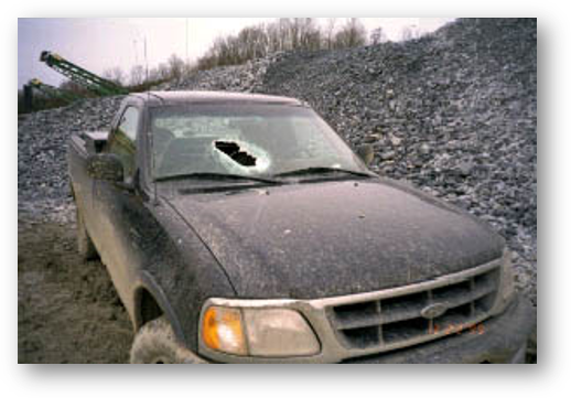 Image from MSHA
One bad flyrock can cost much more than putting together a bore-tracking program and team let alone the damage to your reputation. Its something really worth it.
5 Key Steps to Overcome the Logistical Challenges
- Create a dedicated team rather than independent regional workers. Lots of things get lost lessons learned the hard way aren't always shared.
- Have dedicated trainers in your organization assigned to new employees that can ensure continuity and consistent quality training.
- Evaluate performance by a single dedicated team leader
- Use Drones to significantly speed up data capture for 3D model creation
- Use a collaborative cloud-based platform to increase collaboration between team members and reduce coordination time. Not having to deal with sharing files back and forth makes a huge difference
If you can optimize the other steps in the process, then you can add the entire boretracking step, increasing safety and quality, and still not loose any time.
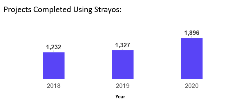
Using Strayos, MD&B's 5 Technicians Can Complete As Many As 20 Sites Per Day- 4 Sites Each.
Key Takeaways
- With a drone 1 person can complete a survey in about 20 minutes per bench. Bore-traking is a 1 person operations.
- Data can be uploaded and processed while driving between between sites
- Quarry planning/surveying is completed in a fraction of the time. Previously alot of time was spent on the ground, sometimes days now it can be flown in 20-30 minutes and be just as accurate. So there's a huge savings on that side of things.
- Flying a drone is MUCH safer for the surveyor/technician- they don't have to be on top of a bench holding up a reflector, they dont have to be on the floor near any heavy machinery, no need to worry about muckpiles or other site hazards.
- Drones are MUCH cheaper and easier to repair and replace than 3D lasers usually $1,500 or $2,000. If one goes down you can just run to a store and pick another one up or order one.
Q & A Session
-
What are the steps that you take after the bore-track data is acquired and how do you upload that into the drone 3D model?
First number the holes and fly the drones. Upload the pictures and get that data processing and the model loading. Then bore-track and get the data. The data is converted into a text file that we upload directly into Strayos. Its super easy. you tell Strayos if its a cable or rodded system and then you're looking at the bench you just flew.
-
What are the best practices and procedures for flying the face to get consistent data?
The best thing that works for me is I do one pass over the top of the shot with the camera facing straight down at about 200 feet. Then ill drop down to about 80 or 85 feet and do 3 more passes kind of staggering your way back from the shot. So ill start over the first row, go back across the second row, and then again over the 3rd row. Then you fly in front of the shot and look back towards the face- at this point it all has to do with the camera angle. The key is to capture the toe and the crest with a little bit of overlap on each side. I've found the camera angle at about 65-70 degrees is kind of your sweet spot- One pass across the face. Then back off a little bit, drop a little lower, set the camera to about 45 degrees and do one more pass across that face.
-
How long are the flight times for this?
Probably about 5 minutes at most. Depends on the shot size, but even a very big shot is probably only about 5 minutes.
-
Are you boretracking all the holes on the shot or only front row / perimeter holes?
Primarily we do it on our face holes- the first row of the shot against the exposed face. Occasionally we can get into the second or third rows, in a few cases the entire shot- If there is serious deviation problems. Some of our accounts require bore-tracking on every hole on every shot.
-
In fact, we are combining 2 processes : - 1 we use the tracker to put in the borehole to collect data. - use drone to capture image and do the 3D modeling. -> then we combine these 2 processes together right ? Please correct me if I misunderstood.
The bore-track data and the drone data generated model are two independent steps. You can generate the model first and design your blast on it then add the boretrak information to it after the holes have been drilled or you can do the boretrak data and the 3D profile at the same time and upload them together. The second method doesn't allow you to compare the drill plan to the execution however, but you can still see the deviation and get the burdens.
-
So the two main benefits of the bore-tracking is to know the hole direction and to know the rock type/volume so as to know what amount of chemicals to use in blasting?
The main benefit for us is the hole direction and the deviation. Knowing how much burden you have on different parts of your holes lets you adjust the loading. If you don't know what your burdens are you can create fly rock. So the main benefit is avoiding fly rock.
Obviously, you can get better breakage if you're confident in where the holes go. Sometimes you need to put as much explosives as we safely can in the holes to break the rock. So if a blaster's not confident he's going to be more conservative with his loading.
It's a big piece of mind tool for the blaster more than anything.
-
Has this helped improve the drilling for the next shot? Are the drillers getting better at understanding the angle, structure, & geology?
It's definitely helped us out alot Ravi. When I send the reports out to the blasters I send it to the driller too because they like to see the deviation, know where the holes are going and they're always correcting themselves- turning their impact down a little, the air pressure up, and setting up slightly different. And they'll ask me when i show up next time "how they look this time? how's everything?" The drillers enjoy it. They like the pat on the back when the holes look good and they like to know what's going on and be able to adjust.
-
We are looking for a new drone for drill & blast. Could you give advises on choosing the right drone for the job?
We're using the same drone throughout the company, the DJI Phantom 4 Pro. The next drone up from DJI is the Inspire, but i really can't find anything else that I think gives us any more of a benefit than what we have currently for how much more they cost. I believe the Phantom 4's are right around $1,600-$1,800 brand new. It does more than everything we need it to. The Camera's great flat, plenty of battery life, and we fly them in some pretty significant winds and rain and snow.
-
How long does the battery last? What size site are we talking about?
If we're in a normal day, calm winds, nothing crazy, you get about 28- 30 minutes of flight time out of one battery. On really windy days or cold days in the winter that can drop in half or more. But a general flight of a bench would just be doing a scan for bore-track and for a shot is only about 5 minutes of flight time. I go through about a battery a day and charge it overnight.
I always keep 3 batteries on me. some of the quarries we have, the sites are hundreds of acres and it can be 2 or even 3 full batteries to do an automated full quarry scan or fly over.
-
What is the maximum depth of measurement inside the hole with drone for understanding deviation?
The drone is generating the 3D model, its not limited as long as it captures the bench height and all- it takes the measurements from there. The borehole deviation information that's coming from the bore-tracking device, is used as a reference point for understanding the maximum depth. So there's no limitation there.
Except maybe the length of the bore-track cord? the cables we're using is 35 meters or about 105 feet or so and we've only ever run into 2 or 3 times where we had a hole deeper than that.
-
Have you seen any dramatic changes between 'pre-drilling timing design' versus 'post survey' design?
Any significant changes to the timing after you boretrack the shot? We've seen it a couple of times with extreme deviation where you may have a second row hole that ends up in front of a first row hole, and becomes your new first row hole, then you need to switch around your timing. But usually we just stick to the same plan.
Only in very extreme cases.
-
When you have close neighbors, does bore-tracking help with vibration issues?
So fragmentation = lower vibration. If the blaster's confident in the loading because he has the bore-track data and he's able to get the front row moving out in a better manner than if he was more conservative, then definitely you'll lower your vibrations because your subsequent rows are going to be moving that much better as well.
-
How high are you flying?
I do one pass at 200 feet and then I'm usually down around 85 feet for the rest of it around the bench. but it depends on the height of the bench and the camera angle.
For quarry fly overs I'm usually around 300-350 feet depending on what's in the quarry- sometimes there's a high conveyor tower or crusher or something and you want to be sure you clear it.
-
Are you able to import already processed data or do you have to process the drone images in Strayos?
Yes, you can import the already processed data such as your geotiff and the 3D model can use that to add to your analysis.
-
Is Phantom 4 RTK worth it?
Depends upon your workflow. If you are constantly flying large sites and you don't have time to put down GCPs then its definitely worth it and if you're flying even more larger areas beyond 30 kilometers I would suggest PPK option because that way you can have the consistency and not loosing signal from the RTK.
For More Information...
Aaron Flewelling: aflewelling@md&b.com
Zadok Emerick: ZEmerick@md&b.com
Ravi Sahu: Ravi@Strayos.com
![]()
What's next for your business?
Change is coming fast and it can feel overwhelming, but those who can adapt gain huge competitive advantages. Technologies like those described above and AI to make true use of the data will give advance warnings and enable real time responses. Using the data available to you you'll be able to adjust your operations to maximize productivity, efficiency, safety, compliance, and so much more.
Time to dig in.
Want More?
Check out our 2 Free E-books:
AI Guide for Drilling and Blasting
AI Guide for Mining