Finding the Seam: Auto Detecting Geology with Drones to Optimize Blasting
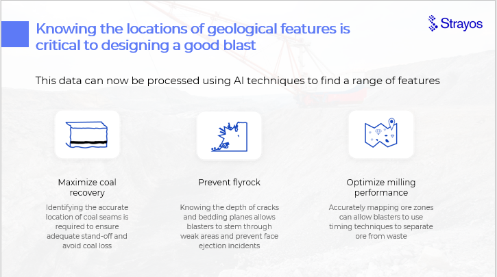
Bench geology is easier than ever to add to your blast design. With automated detection and modeling you can optimize your blast. Prevent ore loss, reduce dilution, avoid flyrock, and more.
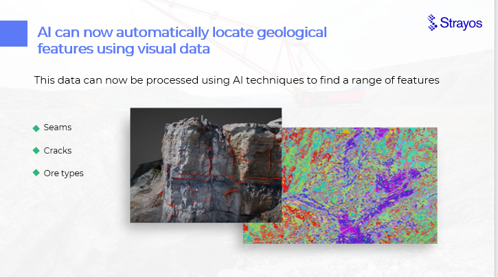
Strayos computer vision AI takes data captured by drones (and other devices including satellites, smart drills, etc.) and uses it to build a 3D model of the bench AUTOMATICALLY. With this digital Twin blasters can now see their bench on the computer and see it's bedding planes, seams, cracks, and discontinuities, and their dip direction and angle and strike angle, and then design blast plan. Other data to incorporate for the best blast: hyperspectral data to SEE the ore on the face of the bench, or look inside the bench with Measure While Drilling, core samples, and touch coal drill data.
If you'd rather watch the webinar- you can view the recording whenever you want here.
Introducing: Brad Gyngell!
It was an exciting hour, with blasting optimization expert Brad Gyngell discussing how new types of data collected by drones and analyzed by AI can be used to create a geological model of your bench and optimize blasting operations. His engaging style and knowledgeable discussion ensured the webinar was fun as well as interesting and drove high levels of attendee engagement. We can't wait to see what subject he wants to discuss next!
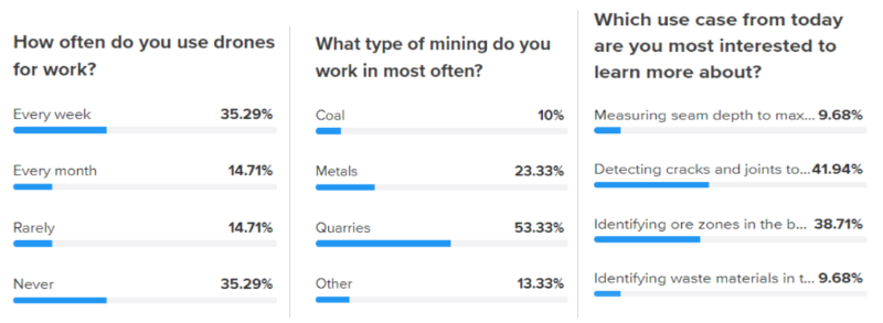
The Audience
Over 250 people registered and over 150 people attended from all around the world. We learned some fascinating things about them!
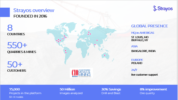
A little bit about Strayos
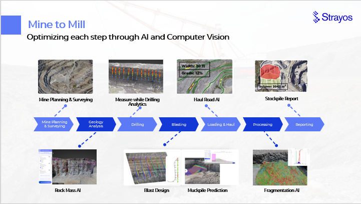
Brad started with a brief introduction of Strayos and a quick walk through of the Mine to Mill Strayos AI product value chain.
Then he dug right in.
New Sensors & New Tools = More Data & More Insights
With the proliferation of accessible sensor technology and new methods of data capture (drones) there has been an explosion of data available to blasters, drillers, mines, and quarries. Before, this data would have been nearly useless due to its massive quantity and granular details, but with the recent developments in Data Analytics and Artificial Intelligence the mountains of data can be processed and digitalized quickly creating site digital twins allowing never before available insights.
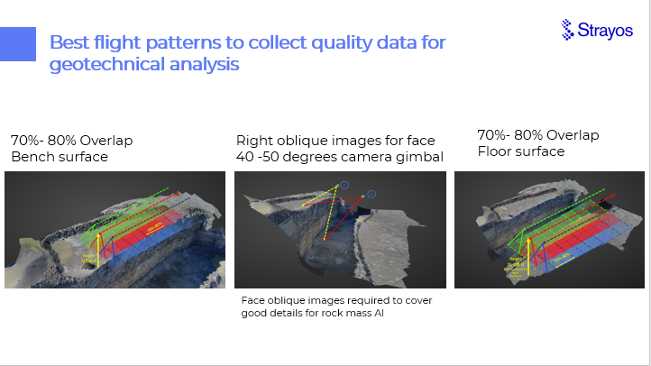
Drone Data Collection Best Practices
The best thing you can do when using drones to capture bench face data and create the best possible 3D Model is to have a good flight plan. Good flight plans collect images with 70-80% overlap and make sure to get several oblique angles of the face along with the bench top and floor. The overlap is critical so that all the corners and crevices are covered. The AI can't create a model or analyze the data if it's missing information- so make sure to get good coverage!
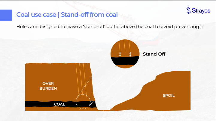
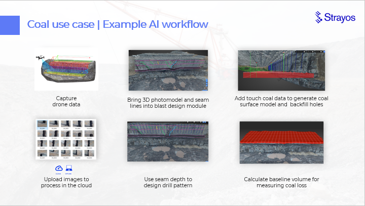
Ensuring proper standoffs to prevent ore loss: Coal Use Case
Leave a standoff between the coal seam and the drill holes to act as a buffer so that the coal is not accidently pulverized during the overburden blasting. Seems so easy...
However, the problem with deposits is that they aren't always flat. Without being able to properly model the seam we run the risk of accidently drilling too close and destroying the coal or not drilling far enough and adding significant unnecessary labor.
Modern modeling techniques eliminate many of the challenges faced by traditional techniques like
- drilling every few holes to touch coal may not pick up discontinuities
- drilling every hole to touch coal adds hours of backfilling
- Gamma logging every hole can take 30+ minutes per hole
- Manual photo comparisons don't give accurate depth measurements
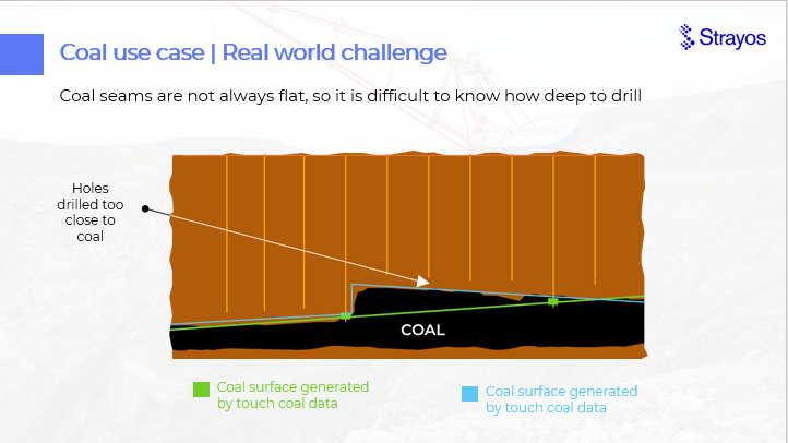
First, images are gathered by drone, then Rock Mass AI analyzes the images and automatically gathers and models the data on the bedding planes, joints, discontinuities, their dip plane and direction and the strike angle from the bench face. Next, by adding to it touch coal data, the seam data is verified and refined. We could further the analysis and blast design by considering data from previous bench models, core samples, or smart drills.
This same principal could be applied to other types of deposits that require the movement of overburden to access a seam, for example phosphate.
Once the seam model is ready simply design your blast on top of it.
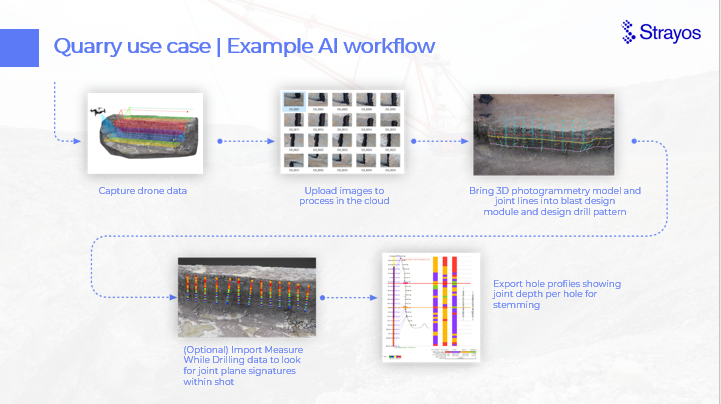
Stemming Through Joints: Quarry Use Case
Joint planes can be a significant problem for blasters, and mine and quarry owners alike. Explosive gases escaping through them risk not only dangerous fly rocks but also disrupting other blast holes. For flyrock this is a huge potential liability, for blast disruption its wasted materials, time, and a poor blast outcome. The best solution to avoid these potential losses is to stem through the joint plane.
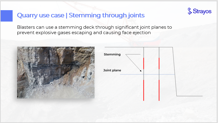
Planning your stemming is easy when the joint is automatically detected and added to the 3D model. The model will show you the joints, their depth from the bench top and height from the floor and their dip angle and direction, and strike direction. All you have to do then is design your blast on the model taking into account the joints when loading the shot.
Even better, if you have a smart drill, you can add to your model Measure While Drilling data for your holes to further verify and supplement the joint plane model
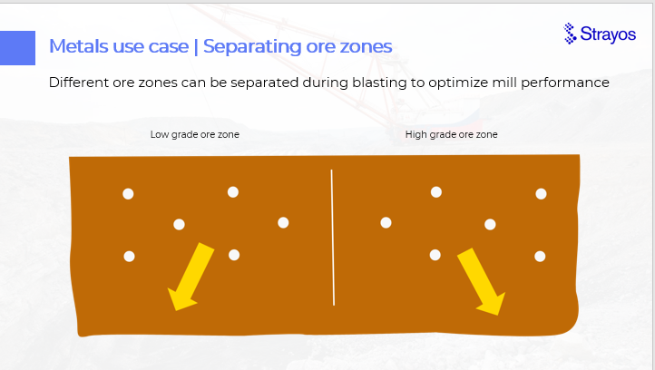
Metals Use Case: Separating Ore Zones
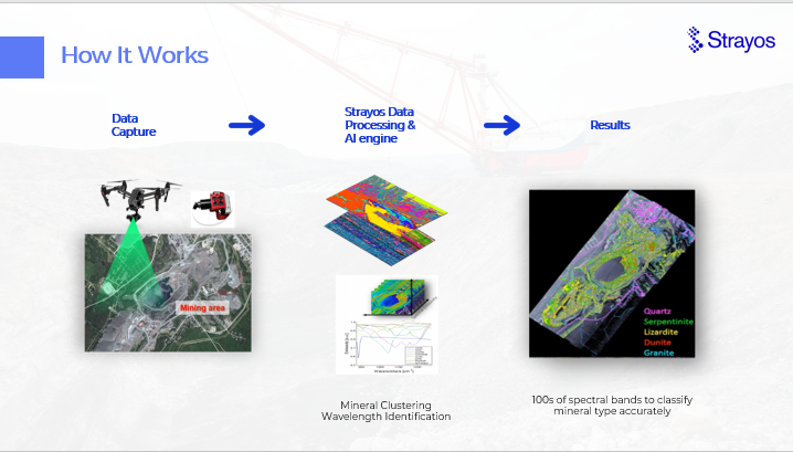
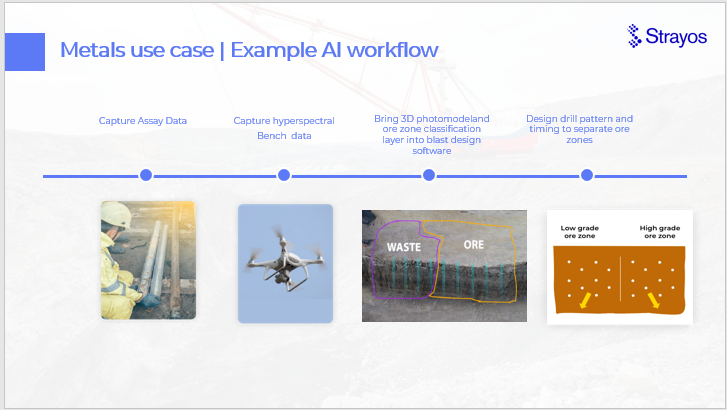
Using hyperspectral Imaging data the software creates a model of the different spectral bands and their corresponding mineral locations. This can be done during exploration, at the mine level, on the bench, or in the muck-pile.
Blasting can be designed to target specific minerals, remove waste, or even to separate ore zones by manipulating the timing in the blast design.
The problem is, current ore zone classification methods- like assay holes, are insufficient to create the most accurate models.
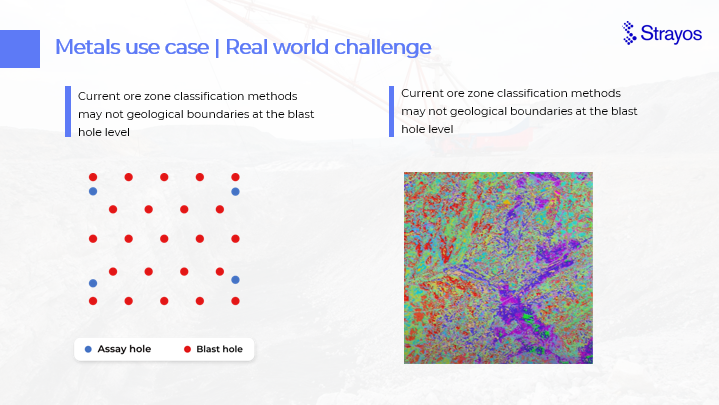
But by combining assay hole data with hyperspectral imaging a better blast can be designed.
Quick Caveat: Hyperspectral Imaging is NOT the same as ground penetrating radar. It detects SURFACE mineral data. It should be combined with other forms of data like Rock Mass, Assay holes, MWD, etc. to develop a full model.
Quick Caveat 2: if used for a rapidly changing environment- like a muck-pile as its being cleared, there should be repeated scans to continually map the new surface as the previous surface rock is being cleared away. It can however give a good idea of where to start with a muck-pile.
Q & A Session
We were asked some great questions during the presentation, here are our answers:
- What type of case studies did your team complete to verify the joint ID? What MWD properties do you focus on?
We have worked with geotechnical specialists for ground truth verification of joints and discontinuities in the highwall detected by AI. While Strayos accepts all types of MWD data generated by drill machine and generates visual representation in 3D model but we have noticed Penetration rate and Feed pressure is commonly used by blasters to apply in their loading decissions.
- How does the Strayos platform integrate and exchange data with other systems on-site including mine planning systems, etc ,etc??
Strayos generates industry standard outputs that can be easily exported out of platform and imported to any 3rd party mine planning softwares. Few examples of standard outputs generated in Strayos platform :
- DXF
- LAS or PLY
- DWG
- SHP or KML
- CSV
- GeoTIFF
- OBJ
- Have you explored many use case opportunities with the hyperspectral cameras in Quarry applications? Maybe to identify different rock competencies or rock types/properties?
Hyperspectral imaging has several use cases in Quarry applications and its at the beginning stages of adoption curve. We think that following applications will bring enormous benefits to quarry applications:
- Ore sorting - true fragmentation and fines detection.
- Maximizing the extraction of ores.
- Classifying the seams to improve drilling accuracy
- Conveyor belt monitoring - Real time ore dilution tracking and foreign objection detection
- Rock properties identification more frequently
- In your experience, how much more exact are the models based on RTK or PPK drone pictures and/or the use of gcps?
We have seen best results in using GCPs and PPK as it ensures the data reliability for survey grade measurements. Using RTK gives the freedom of real time corrections of images and its also a reliable choice but if there is a loss of connection to the base station then the accuracy of the data will hamper.
https://help.strayos.com/hc/en-us/articles/360035634413-Strayos-PPK-User-Guide
- is the hypserspectral image data collected as individual photos or are they merged together to create 3D models similar to photogrammetry?
Hyperspectral images are collected as individual photos and can be used to generate a final map for the analysis. Hyperspectral sensors mounted on drones and satellites can collect images over a large geographical area which can be automatically analyzed by algorithms to map the properties of materials in the scene. The analysis of hyperspectral images is different than usual RGB images. Hyperspectral sensors captures the reflected or emitted electromagnetic energy from a scene over hundreds of narrow, contiguous spectral bands, from visible to infrared wavelengths. Each pixel in a hyperspectral image is composed of a vector of hundreds of elements measuring the reflected or emitted energy as a function of wavelength, known as the spectrum. The spectrum captures the information about the material’s chemical and physical properties because the interaction between light at different wavelengths and the material is governed by material’s atomic and molecular structure.
- any thoughts on use of this work flow process and technology in UG mining??
These technologies can be applied in the same way for underground mining to detect geological features. Drones have been shown to be very useful in navigating the smaller confines of UG mining as well s for any vertical mapping such as ore passes. The differences would likely be in the way engineers would use this data to improve mining outcomes for example, LiDar would be a very useful addition to the mapping and modeling part as it works well in low light/poor light situations. This geological information would likely be useful when planning new drives, stopes etc.
- can it detect water level in different holes and design charging accordingly?
Strayos does not yet offer this product, but we would be happy to work with you to develop it.
To see the whole thing in action watch the Webinar Replay here.
What's next for your business?
Change is coming fast and it can feel overwhelming, but those who can adapt gain huge competitive advantages. Technologies like those described above and AI to make true use of the data will give advance warnings and enable real time responses. Using the data available to you you'll be able to adjust your operations to maximize productivity, efficiency, safety, compliance, and so much more.
Time to dig in.
Want More?
Check out our 2 Free E-books:
AI Guide for Drilling and Blasting
Watch
the Webinar Replay
our YouTube videos*