Webinar Summary: Enhancing Drilling & Blasting with Geospatial Data
Webinar Replay
https://youtu.be/LiKCRGMO1qE?feature=shared
Download Slides
https://campaign.strayos.com/enhancing-drillandblast-slides
Summary
Every day, quarries and mining operations capture vast amounts of valuable data—subsurface information, geological maps, blast performance metrics, and more. But how effectively is this data being used? Traditional pen-and-paper logs fall short of unlocking the full potential of your operation.
Enter Geographic Information Systems (GIS)—a cutting-edge solution that connects data to maps, combining real-time and historical information into actionable insights.
Discover how Geospatial Data can help you:
- Transform Data into Actionable Insights: Learn how Geospatial integrates location data with operational metrics to optimize quarry management.
- Advanced D&B Planning with GIS: Understand how GIS improves blast design by incorporating geological data, MWD (Measure While Drilling) insights, & environmental factors.
- Enhancing Safety & Compliance: See how GIS aids in monitoring haul roads, equipment placement, & environmental conditions.
- Short- & Mid-Term Quarry Planning: Dive into how Geospatial supports strategic planning with geological block models, volume calculations, & ramp designs.
- Continuous Improvement with AI & GIS: Explore how Strayos integrates AI & machine learning with GIS for post-blast analysis & process refinement.
Meet Your Expert Guide Join Elijah Williams, Senior Solutions Engineer, as he demonstrates how to integrate GIS data into your quarrying, drilling, & blasting workflows. Elijah will reveal how this technology transforms complex datasets into powerful tools for safety, efficiency, & profitability.
What You’ll Gain
- A roadmap to modernize your operations with Geospatial Data.
- Insight into real-world applications & success stories.
- Strategies to save costs and boost productivity by leveraging your data.
Don’t Let Valuable Data Go Unused! In today’s data-driven world, the ability to effectively manage and utilize geographic information is a game-changer.
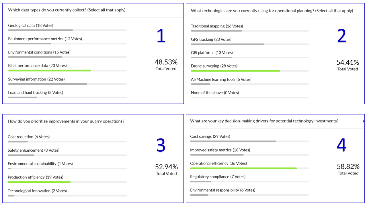
Polls

Questions & Answers
- Do you recommend maintaining the same flight elevations?
Yes, for consistency in results, it is best to establish a flight plan that can be repeated.
2. What tool/ technique do you use to track back post-blast muck to in-situ drillholes?
Strayos’ post blast tools can overlay in-situ boreholes for analysis of movement, fragmentation and backbreak.
3. What opportunities are there to incorporate enterprise GIS services into Strayos, and what opportunities are there to automate Strayos data into an existing enterprise GIS?
Strayos has integrated APIs that can be used for GIS integrations. Reach out to our team for more details.
4. Do you recommend using zoom to do muck pile fragmentation?
Zoom is not recommended. Capture images with the cameras standard frame.
Presenter

Elijah is a Civil Engineering graduate, who has served the drilling and blasting industry for almost 8 years. As a licensed blaster, his blasting experience lies in quarry and construction operations along the East Coast of the US. Currently, as a Senior Solutions Engineer, he is assisting in the operations of others by implementing technology to help improve the safety, efficiency, and production of mines and quarries on a global scale.

New technologies are rapidly changing the drilling, blasting, mining, and aggregates industries, empowering them in ways never before possible. Make sure you are taking advantage of the best tools available.
Check out our 2 Free E-books on AI applications for the drilling, blasting, and mining industries to see all the amazing advances that are available.
AI Guide for Drilling and Blasting
AI Guide for Mining
Watch our videos:
YouTube
